The team behind Google Earth released an update to the timelapse feature of its satellite imagery app, and it’s a great way to see the rapid pace of urban development and public infrastructure projects like the San Francisco Bay Bridge, The Verge said. The feature lets anyone jump into any location and watch as is morphs over the years. But there’s another, more sobering and necessary function of Google Earth: seeing how human-driven climate change has transformed the planet in just 32 years time.
The new update adds another four years of data — stretching now from 1984 to 2016. It also includes petabytes of high-resolution imagery from two new satellites, Landsat 8 and Sentinel-2, so we can see in even clearer detail the effects of carbon emissions and other manmade factors on glaciers, sea levels, and forest lines.
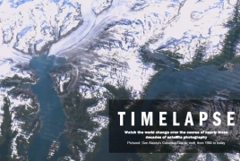
As Popular Science points out, an obvious example is the recession of the Exit Glacier in Alaska's Kenai Peninsula. You can also jump over to the coastal areas of Louisiana or the bodies of water in Nebraska to see how the effects of natural disasters and droughts are exacerbated by climate change. To check out the timelapses for yourself, head over to the Google Earth Engine and start exploring, The Verge said.