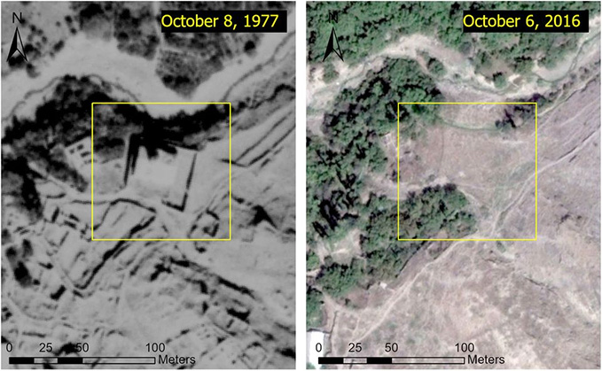
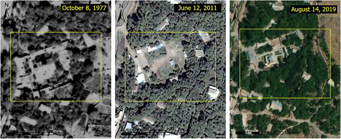
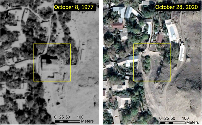
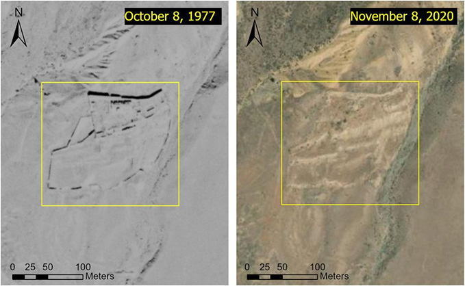
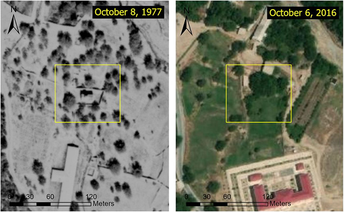
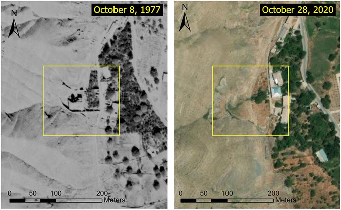
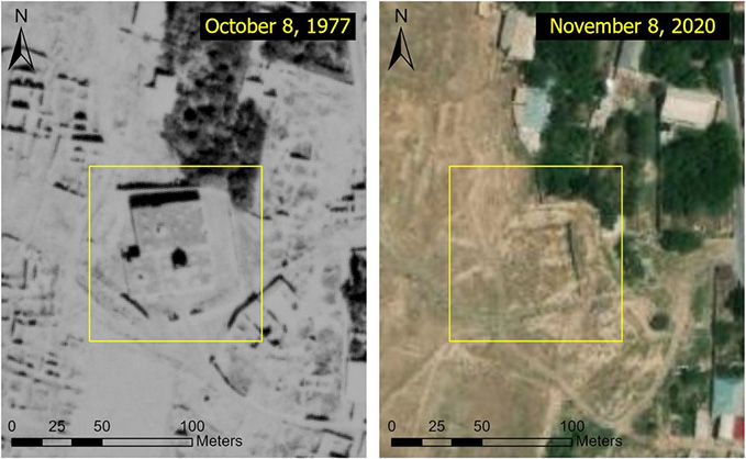
Satellite images show erasure of Armenian churches in Azerbaijan June 2, 2021 - 17:03 AMT PanARMENIAN.Net - Covert destruction of Armenian-Christian heritage in Azerbaijan’s autonomous republic of Nakhichevan has been exposed in recently surfaced Cold War spy imagery taken by the United States in the 1970s. Researcher Simon Maghakian, who is a visiting scholar at Tufts University, Massachusetts, and a lecturer at the University of Colorado Denver, has analyzed the newly-available information and images and published a comprehensive investigation for the first time. For more than 2,000 years, the indigenous Armenian population of Agulis and the wider canton of Goghtn (Azerbaijan’s present-day Ordubad district) created a unique culture. But Goghtn’s Armenian existence was terminated in the past century—first during the First World War-era Armenian Genocide, then in a complete physical erasure of all cultural remnants, following centuries of miraculous survival. The “Kuwait on the Caspian” continues to deny Agulis’s Armenian past. It also bans researchers from exploring the town. In 2013, the independent Russian journalist Shura Burtin managed to briefly sneak in, just long enough to see that no churches or cemeteries were left. "As the post-Soviet flattening of Armenian heritage in the Nakhichevan region comes into view through declassified Cold War satellite imagery—affirming Aylisli’s eyewitness account—new threats seem to loom. Following the November 2020 ceasefire to the Second Nagorno-Karabakh war, approximately 1,000 antique and medieval Armenian cultural sites are now under Azerbaijan’s control. To say that these sacred heritage sites are at risk might be a monumental understatement," Maghakian said in hia article published by The Art Newspaper. While magical Agulis is forever gone, recently declassified materials offer help in reconstructing its erased historical landscape. A rare positive side-effect of the Cold War was the mutual clandestine map-making and satellite imagery collection activities by the US and the USSR. Thanks to these, the precise locations as well as discernible images of the major churches of Agulis have been preserved. All are from the 1970s, including two maps produced by the USSR General Staff’s Office that list all the major churches, and geospatial imagery produced by the US’s declassified spy satellite programmes. These before-and-after satellite images are published for the first time. Surb Stepanos (Saint Stephen) Surb Tovma (Saint Thomas), one of the largest and most important monastic complexes of medieval Armenia Surb Kristapor (Saint Christopher) Mets Anapat Surb Astvatsatsin (Greater Hermitage Holy Mother of God) Surb Hakob Hayrapet (Saint Jacob of Nisibis) Surb Hovhannes Mkrtich (Saint John the Baptist) Amarayin "The USSR General Staff map pinpoints half-a-dozen cemeteries and many more ruins. Due to substantial challenges involved with identifying medieval cemeteries (combined, Agulis had approximately 2,000 historical tombstones, many of which were photographed and sketched by Ayvazyan in the 1970s and 1980s), we refrained from identifying the cemeteries or other ruins, including the large remnants of Surb Shmavon (Saint Simon the Zealot) church," the article said. The EU does not intend to conduct military exercises with Armenia, Lead Spokesperson for EU Foreign Affairs and Security Policy Peter Stano says. A telephone conversation between Putin and Pashinyan before the CSTO summit is not planned, Peskov says. London’s Armenian community has been left feeling “under attack” after the city’s Genocide monument was vandalised. The United States believes there should be an international mission to provide transparency. Partner news |